


About Me
Welcome to my Portfolio
I am Opeyemi, a GIS analyst, with experience applying GIS in business (Sales and Logistics planning), and in hazard mapping (using Remote sensing products). I constantly seek to improve my skills for the optimal application of Earth observation data and locational intelligence, in tackling real-world issues through continuous learning and improvement.
By so doing, I am privileged to be a part of the prestigious Copernicus Master in Digital Earth, fully funded by the Erasmus Mundus Scholarship program, where I am being trained by the greatest minds in Applied Geoinformatics and Remote Sensing.
I am currently seeking internship opportunities full-time (Summer)/part-time (Remote).
Interests
GIS and EO for Disaster Risk Reduction
Exploiting accessible Earth Observation data and tools for improved emergency preparedness in disaster situations
EO for Sustainable Development and Urbanisation
Utilizing Earth Observation data to ensure sustainable development and urbanisation
Geospatial Education and Communication
Spreading the Geospatial gospel across Africa and beyond
Resume
Education
2022 - 2024
Copernicus Master in Digital Earth
University of Salzburg, Austria Palacky University, OlomulucSpecialization Track: Geovisualisation and Geocommunication.
With funding support from the Erasmus Mundus Scholarship
2019 - 2022
Master of Buisness Administration
University of LagosSpecialization: Marketing
2012 - 2016
Bachelors of Science - Geograpahy
University of IbadanExperience
July 2021 - Current
Geospatially Africa Podcast
(Host) Media and CommunicationI source and contact trailblazing initiatives, talents, and innovations that are optimally harnessing the power of geospatial, interview them, and produce the episode on all platforms
September 2020 - January 2023
Geohazard Risk Mapping Initiative (GRMI)
Volunteer GIS Analyst / Team Lead (Research and Innovation)Responsible for improving the efficiency and accuracy of hazard mapping processes, by introducing modern and state-of-the-art methods and organizing training to implement them across the volunteer structure.
May 2021 - April 2022
DASS Geospatial Services
Geospatial Data Analyst (RTM Team)Developed and implemented GIS-enabled workflows to effectively manage clients' sales and output logistics activities, reducing average processing times by hours.
May 2021 - April 2022
Women+ In Geospatial
Regional Ambassador (Volunteer)Coordinated 2 events with team members and partner organizations addressing new trends in the African geospatial space, aimed at uniting the community and inspiring members and potential members to join. Both events garnered 200+ participants and 1000+ views so far on Youtube.
Skills and Software
Portfolio
Hover over each block to view summary, click to view details
EMCDE Diploma Thesis
3D GIS
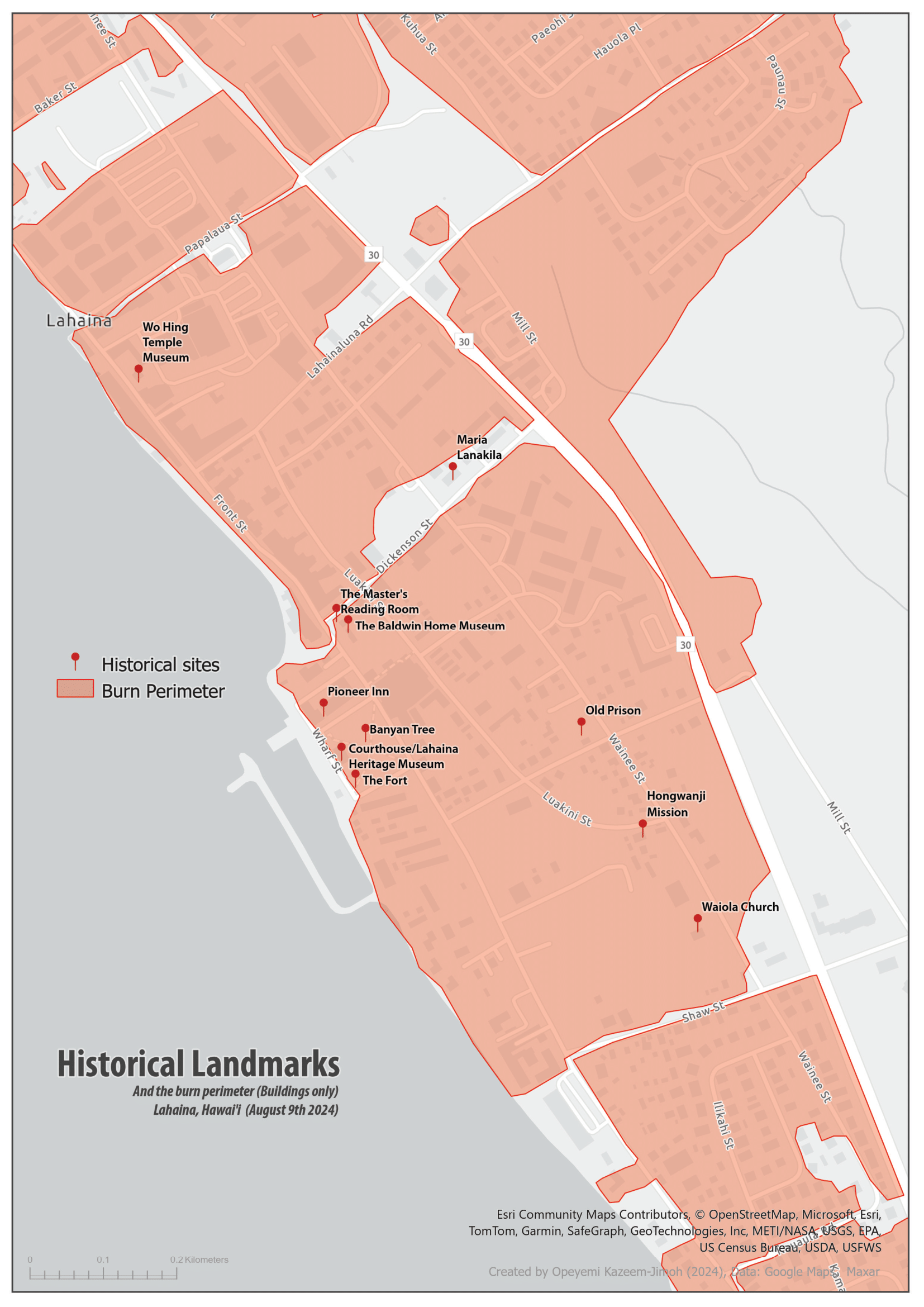
3D Visaulaisation of 2023 Maui Wildfires
Tools: Blender, Adobe Premier Pro
RSensePy
Python Programming
Vegetation Index Calculation Python Package
Tool: Github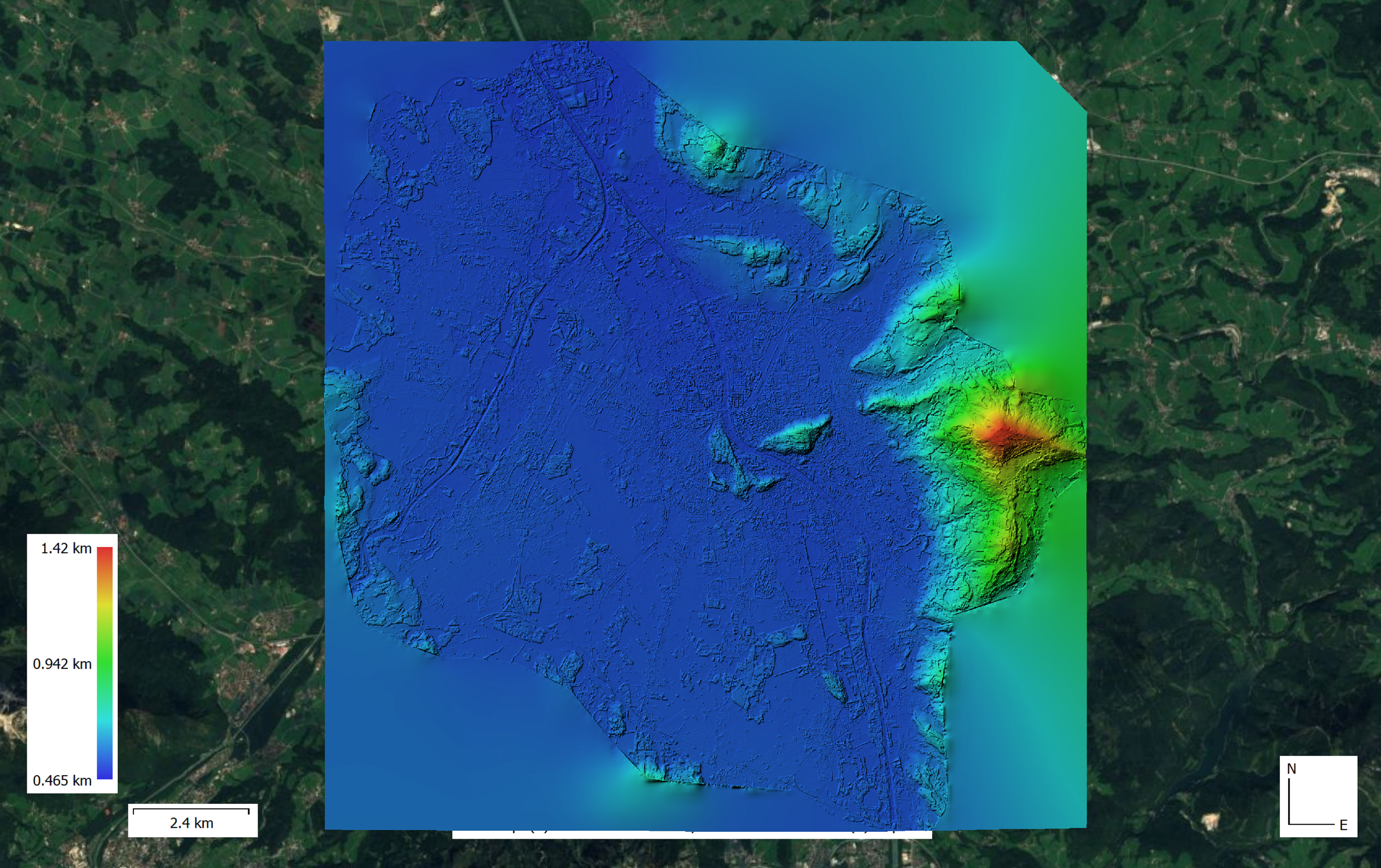
Tri-Stereo Photogrammetry (DSM creation)
3D GIS
Tools: Agisoft Metashape, MicMac
Solar Radiation Potential
Spatial Analysis
Estimating solar potential of built structures in an urban setting
Tool: ArcGIS Pro
Terrain Analysis
Spatial Analysis
DEM analsyis to better understand morphometric properties of the surface and its impact on topological process

Not in my Backyard (Viewshed analysis)
Spatial Analysis
How much will a planned skyscraper affect visibility in an Alpine Winter Wonderland.
Tool: ArcGIS Pro
Watershed Deliniation and Visualization
Cartography
Tool: QGIS
Big Earth Data
This class covers state-of-the-art tools and techniques for Big Data Analysis in the contect of Geospatial Data. Click to explore some sample projects done for the class
Tool: Google Earth Engine, EO Browser
Geo-humanitarian Action
Seminar
Exploring the application of EO Data cubes in Conflicts situation
Tool: Sen2Cube.at.jpg)
COVID-19
Result of a survey analysing the Impact of COVID-19 in the average Nigerian Houshold
Tools: ArcGIS Online, ArcGIS Dashboard, Survey 123
Podcast Host
Geosaptially Africa Podcast

Object Based Image Analysis
Remote Sensing
Satelite Image Classification and Analysis using E-Cognition 9.1
Tool: E-Cognition
Flood Succeptibility Mapping
Flood Risk Analysis
Using multicriteria approach and weighted overlay analysis to estimate potential flood risk
Tool: ArcGIS Pro
Internship
Spatial Services
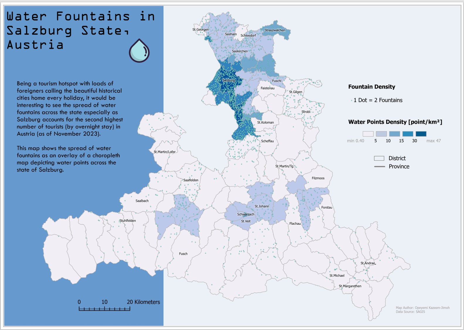
Water in Salzburg
Cartography
Accessing water points availability in Salzburg in a Dot-density Map.
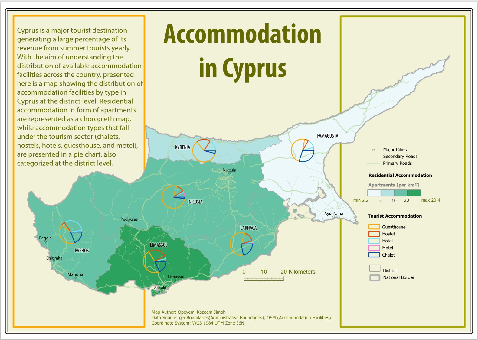
Accomodation in Cyprus
Cartography
Accessing the types of Tourist accomodation prevalent in Cyprus in a thematic map.
Blog
My Diary


Contact
Get in Touch
Do reach out to me through the form below, or via the social media links above